As we get closer to Thanksgiving, many are finalizing guest lists and dinner menus. However, another subset of Americans are feeling called to acknowledge the real history behind this holiday, the one that doesn't involve the pilgrims and Native Americans peacefully sharing a feast. One way to acknowledge all that Columbus and his settlers did upon arriving in America is to learn which Native American land you live on, and this native land map is a good place to start.
When Columbus and the European settlers arrived in the United States and "discovered" America, their plan was to start a new nation. However, finding groups of indigenous peoples with well-established societies and territories wasn't on the agenda.
The System of Land Treaties
To deal with this unexpected roadblock, the settlers set up trade agreements with the Indigenous nations, offering goods in exchange for Indigenous lands. This was the beginning of colonialism, and eventually led to the Indigenous territories in the United States and Canada being taken over by the settlers.
Although these treaties between Indigenous communities and the newcomers started off seemingly peaceful, the European settlers eventually breached their contracts, resorting to war and forced treaties when they weren't able to obtain the land they wanted from the Indigenous groups.
In 1786, the United States established the first Native American reservation, with the plan of moving native people onto the designated lands, so that the newcomers could create settlements on their land. The government approached each tribe as an independent nation, pressuring them to move onto the reservations created for them.
The Trail of Tears
However, when this system wasn't successful in obtaining the American Indians' land, the United States government resorted to new measures. In the 1820's, the Removal Act was passed, which forced Native Americans to leave their homelands and settle in the territory chosen for them west of the Mississippi River.
This was what eventually led to the "Trail of Tears," when thousands of Cherokees were forced to march 1,000 miles, thousands of them perishing along the way. This website goes into further detail about the Indigenous history of land being taken by European settlers.
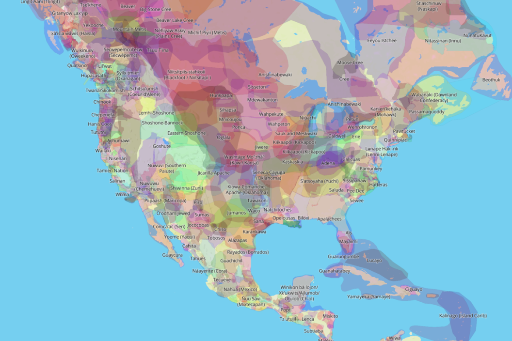
Whose Land Are You On?
In an effort to acknowledge this history, Victor Temprano of Native Land Digital created an interactive map. This Indigenous-led Canadian non-profit aims to create space for Indigenous communities to represent themselves and their histories on their own terms, inviting non-native people to learn more about the land they live on and the history of that land.
Whether you live in Alaska or New York City, you can check the map to see which Indigenous people lived on your land before you did. By typing in my address, I can see that the land I grew up on was previously inhabited by the Kiikaapoi or Kickapoo, a tribe that lived in modern-day Indiana.
You can also learn about specific tribes, typing in the name of the tribe to see what parts of the country its people inhabited. Typing in "Oneida" brings you to around New York, while "Potawatomi" leads you to the southern part of Lake Michigan.
The Ojibwe were the most populous tribe in North America, and you can see on the map that they previously lived in modern-day North Dakota, Michigan, Ontario, and more. Although this map is a small step compared to all that's happened in American history, it's one way to become more aware of the past and honor those whose land was taken when the Europeans came to North America.